Buried Waters
Instructor: Dietmar Straub
LARC 7340
Landscape Architecture Design Studio
Anyone who thinks about Winnipeg’s watercourses first thinks about the Red, the Assiniboine and probably the Seine River. These waterways have a powerful presence in Winnipeg’s urban fabric and shape the city’s identity in concert with the voluminous tree canopy. The rivers establish a lush and variable texture to Winnipeg’s urban landscape throughout all seasons and are crucial for the city’s social and ecological life. They are associated with stories, anecdotes and personal experiences.
Rarely are the creeks and streams remembered, which formerly shaped the land now occupied by the city called Winnipeg. A large part of the landscape on which Winnipeg sits today was once marshland or periodic wet meadows. The city has been built over its aquatic topography. The goal of this studio is to reveal the hidden aquatic topography layer by layer and to visualize its location within the existing urban fabric. Reading the ‘text’ of this landscape, the students will identify sites with the capacity for precise spatial design interventions to regenerate connections with the lost waters.
Benjamin Boswick

Karina Leong
Laurel Cowley
Lindsay Mamchur
Benjamin Gaudes
Bryce Stovin
Benjamin Boswick
Aqua Terra Incisura
I am currently pursuing a Master of Landscape Architecture degree at the University of Manitoba after completing my Bachelor of Environmental Design degree in the Landscape and Urbanism stream in the Winter 2021 term. My related experiences include working with various building materials and products and technical drawings, and different types of software such as Vectorworks, Rhino3D, AutoCAD, Photoshop, InDesign, and Illustrator.
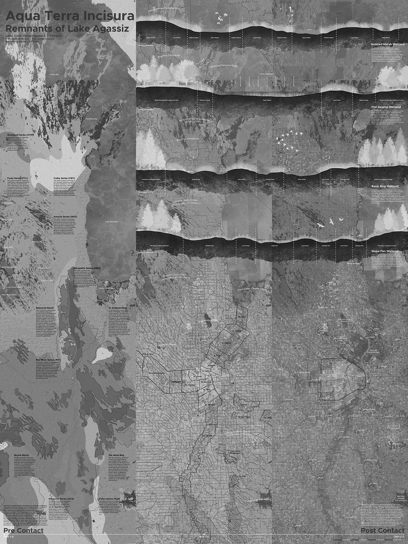
Aqua Terra Incisura is an analysis of southern Manitoba wetlands that exist currently and those that existed before European contact. An adjacent study of soil composition for the region demonstrates the relationship between the remnants of Lake Agassiz and the wetlands. Red River Settlement parishes and current settlements provide regional context. Drains that removed water from the prairies to make land available for agriculture are also shown, along with the extent of existing wetlands. Abstracted sections of various wetland compositions found in Manitoba show select species of vegetation and animals found within these landscapes.
Laurel Cowley
Tri-parian: Three Typologies for Reclaiming Winnipeg’s Creeks
A Master of Landscape Architecture Student who is passionate about inclusive and sustainable public open spaces.
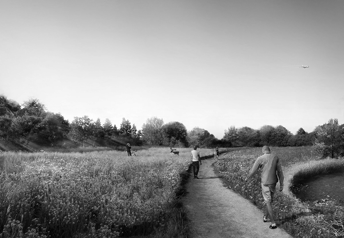
Tri-parian is a layered approach to reclaiming Winnipeg’s existing creeks. The project began by exploring the importance of waterways in pre-contact Manitoba. The project revitalises three remaining creeks by providing a vegetative buffer around the creeks, protecting them from future urbanisation. There are pathways provided along these creeks, giving people the opportunity to engage with the creeks and the different environments, and plazas for people to rest and relax in. This recreational trail strengthens the presence and identity of each creek. The area around Sturgeon Creek is transformed into a diverse grassland, Truro Creek is surrounded by dense forests, and Omands Creek is converted into a woodland with various trees and woodland wildflowers.
Benjamin Gaudes
Sky Symposium: a Winnipeg Park and pathway system to reveal the prairie skies
I am a 26-year-old, Winnipeg based designer working towards becoming a Registered Landscape Architect. I hold a Bachelor’s Undergraduate Degree in Environmental Design (L+U stream, 2019) and am currently working towards obtaining a Graduate Degree in Landscape Architecture from the University of Manitoba.
Sky Symposium is a celebration between fauna, flora, pedestrians, and the prairie skies. This project proposes a parkway system which connects the rural skies to the urban dwellers of Winnipeg. Sky Symposium is an extension of the developing pedestrian network of Winnipeg’s northwest. Nearing 30km, this parkway stems from a desire to create an increased ecological buffer to the three forgotten creeks of the area: Sturgeon, Truro, and Omand’s. Creek edges increase to 75 meters and include varying types of meadows and tree canopy. Where this parkway diverges from the waterways, pathways use similar devices to connect park users to this areas plane and train presence.
Along its entirety, at 2–3-kilometre intervals, an enticing spatial experience is presented to park users through an expansion in the parkway. These moments in the rural and peri-urban landscapes showcase the most drawing natural lure of Canadian prairies, its sky. Topographies are altered, trees serve as tools to frame, connect, or disconnect, and ground cover is substantially diversified.
Karina Leong
Tran[in]sects
I’m an international student in the Master of Landscape Architecture program. I completed my Bachelor of Environment Design Degree in Landscape and Urbanism in 2018. I am passionate and active participate in design competitions related to art installation, architecture, and landscape design.
Tran[in]sects is a different series of strategies proposed to weave the fragmented landscapes and the three main existing creeks. The main objective is to rediscover the creeks and the vestiges through the implementation of 4 Strategies: Restoring and revitalizing the existing creeks, introducing a linear forest runway that act as the main corridor with edible tree and shrubs, Ribbons of wildflower and field herbs to rejuvenate the farmscape, and designing a proposed water catchment at the end of Truno Creek. These series of strategies aim to contribute to more biodiversity, serve as a retreat for plants and animals in the middle of the intensely used agricultural lands, connect the peri and urban landscape and cities, and provide the habitat and promote “beneficial insects”.
Lindsay Mamchur
Northwest Creek Corridor
I’m a student in the Master of Landscape Architecture program who is passionate about photography, books, and beautiful urban spaces.
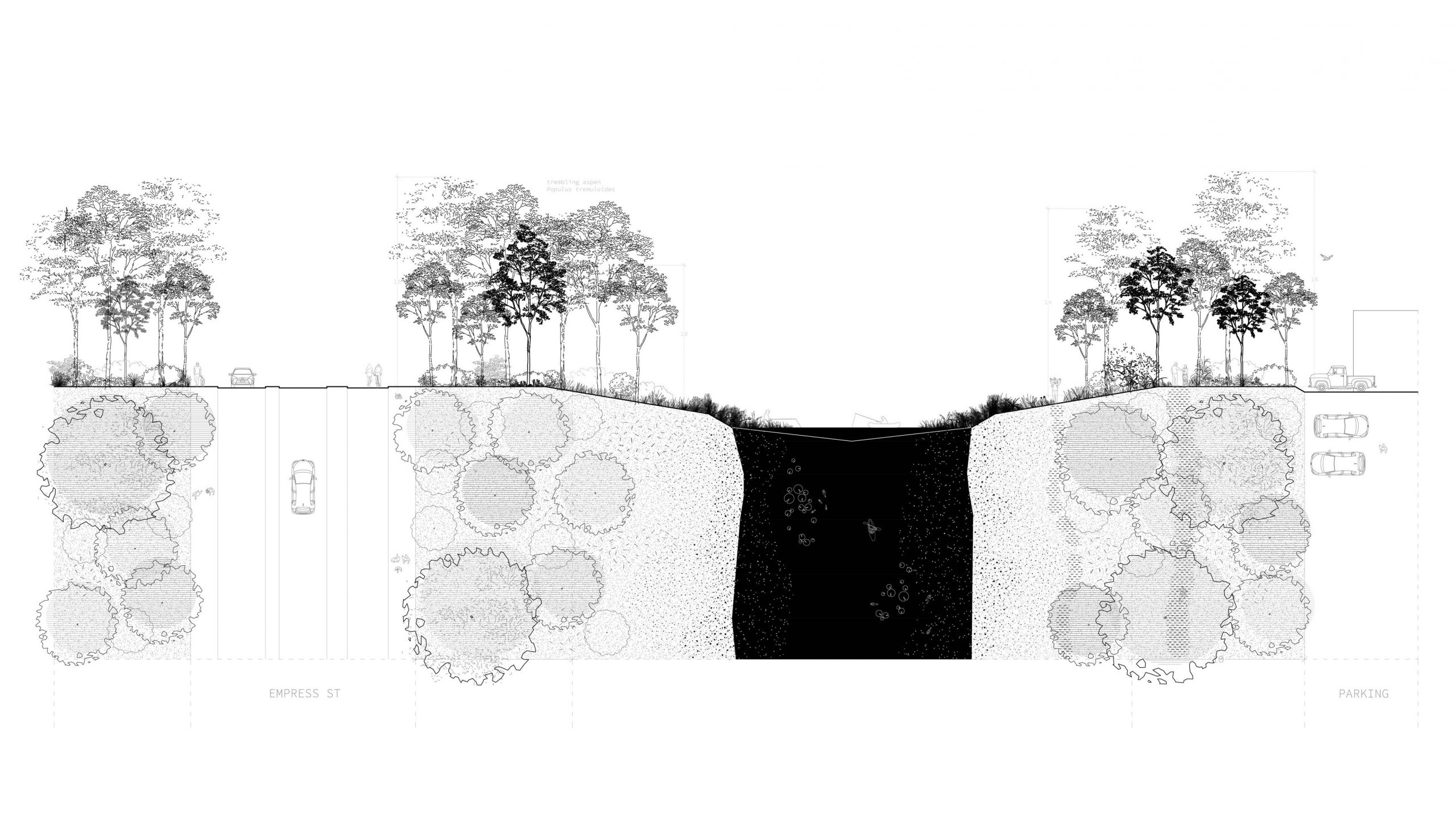
The Northwest Creek Corridor is a continuous creekside public right-of-way, a system of paths nested within a loop defined by Sturgeon Creek, Omand’s Creek, and the Assiniboine River. Ten metres of creek-adjacent land, largely uncultivated and/or flood-prone, is conceded on both sides of the Sturgeon, Truro, and Omand’s Creeks. Through line and grove tree plantings, the corridor links a series of destinations, including the Assiniboine Forest, Westview Park, Brookside Cemetery, and the airport airfield. Tree spaces proposed near farmland help support agricultural and ecological function by sheltering wind, reducing erosion, filtering water, and enriching soil. Ultimately, the corridor works to protect the integrity of Winnipeg’s creeks while also improving public access to and engagement with the water.
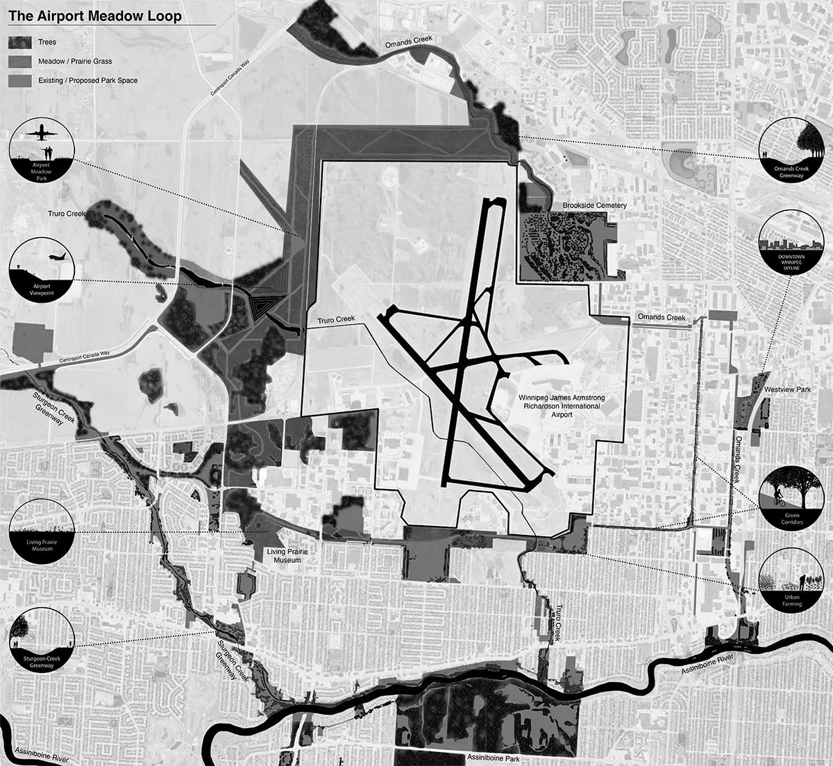
Bryce Stovin
The Meadow Belt
I am currently a student in the Master of Landscape Architecture program where I am an M3 student. I completed my Bachelor of Environmental Design Degree in 2021 before returning to pursue a master’s degree. I am looking forward to starting my practicum work where I hope to explore a topic within sustainable design as we move forward with a warming climate and so much uncertainty.
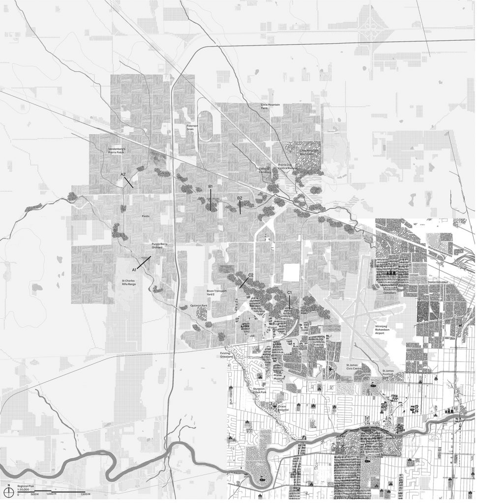
The Meadow Belt is a large-scale project looking at connecting and introducing green corridors and open spaces around the Winnipeg James Armstrong Richardson International Airport. These corridors would act as an active transportation system while also connecting people to park spaces and important destinations in the area. The main feature of the system is a prominent new park on the west side of the airport highlighted by a large mound that can be used for watching planes coming and going from the airport. The park also reintroduces large areas of native grasses to restore a piece of the historical Manitoban landscape.